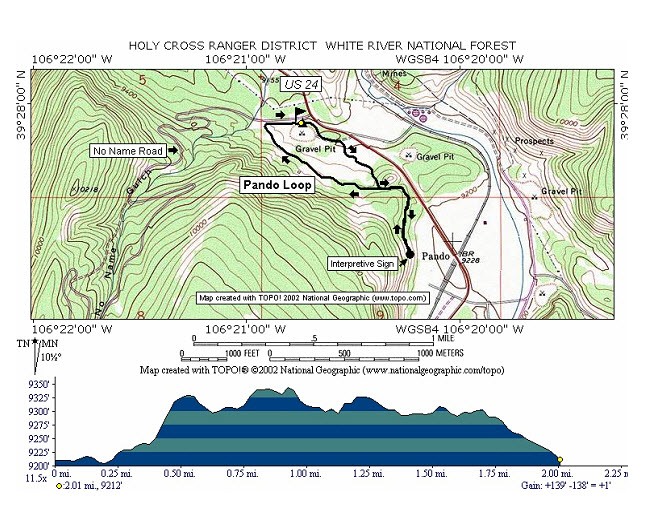
Pando Loop
Length:
2.0 miles (one way)
Trail Use: Light to Moderate
Difficulty:
Easiest to Moderate
Open To: XC, Snowshoe, Snowmobile
Beginning Elevation:
9,212 feet
Ending Elevation: 9,212 feet
Elevation Gain:
+0 feet
USGS Map(s): Pando
Attractions/Considerations
:
An overlook along the trail provides a view of the
Pando
Valley and the north end of the
Camp
Hale area. An interpretive sign explains that the
Pando
Valley once contained extensive ice ponds which provided refrigeration for the trains of the
Denver and Rio Grande Railroad.
Camp
Hale was constructed in 1942. The Army’s 10th Mountain Division was trained here to endure the severe winter conditions of
Alaska and the mountains of northern
Italy during World War II.
Access from Vail
: Travel west on I-70 to Exit 171 for Minturn, Leadville, and Hwy 24. Exit here and turn right (south) onto Hwy 24. Proceed south about 13.7 miles to the
No Name Road (#705) pullout on the right.
Trail Highlights
:
The Pando Trail may be skied separately or in conjunction with the adjacent No Name Trail.
The Pando Trail provides and area for a several hour to half-day tour. The trail is marked with blue diamonds. Beginning at the trailhead on US Highway 24, the trail follows the
No Name Road west for approximately .1 miles. At this point the trail leaves the
No Name Road and heads southeast along an old road, across an open flat, and up a lodge pole pine covered hillside to mile .6. At this point the trail forks. A segment heads east and then south along a lodge pole pine covered bench for approximately .4 miles to the overlook and interpretive sign. The trail then retraces itself back .4 miles to the fork. From the fork the trail heads west and then northwest through lodge pole pine and open meadows approximately .7 miles to the
No Name Road. Near the end of this section is a short descent down an open slope of approximately twenty-five percent. The trail then follows the
No Name Road east approximately .2 miles to the original point of leaving the road and then the final .1 miles to the starting point.
