
MISSOURI LAKES TRAIL
#2003
Length & Elevation Gain:
2.7 miles to first lake (+1427 ft)
4.0 miles to
Missouri
Pass (+1991 ft)
4.4 miles to
Fancy
Pass trail (+1811 ft)
Difficulty:
Moderate to More Difficult
Trail Use: Moderate to High
Beginning Elevation:
10,010 ft
Open To: Hiking, Horseback
Ending Elevation:
11,986
ft.
USGS Map(s): Mt Holy Cross
Access from Vail
:
Travel west on I-70 to Exit #171 for Minturn, Leadville, and Hwy 24. Exit here and turn right onto Hwy 24. Proceed south for 13 miles to
Trail Highlights
:
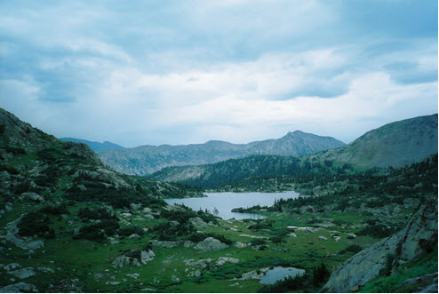
The first mile of the trail passes diversion dams and water pipelines. Just past mile 1, the trail crosses the creek at the mouth of a miniature canyon, creating a breath taking view. The trail winds through stands of conifers and crosses the creek several more times before emerging into a large lush meadow. The trail climbs a short, steep distance to the basin that holds the
Missouri
Lakes . At about 2.7 miles you will see a side trail left that leads to the first of the lakes, a short climb of 100 feet gain in 0.3 miles.
Savage
Peak dominates the view to the south above this first lake. The main trail traverses the basin past several other lakes before reaching the last lake at about 3.5 miles. To get a bird’s eye view of the lakes, continue up switchbacks to the 11,986-foot
Missouri
Pass and back down the other side to join the
Fancy
Pass and Cross Creek trails at 4.4 miles.