
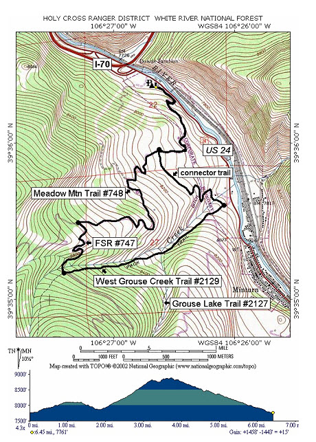
Meadow Grouse Loop
Length:
6.45 mile loop
Trail Use: Moderate
Difficulty:
moderate
Open To: XC, Snowshoe, Snowmobile
Beginning Elevation:
7,750 ft.
Ending Elevation: 7,750 ft.
Elevation Gain:
+0
USGS Map(s): Minturn
Access from Vail
: Travel west on I-70 to Exit 171 for Minturn, Leadville, and Hwy 24. Exit here and turn right (south). Just past the interstate, there is a large parking lot on the right. The trail begins from the south end of the parking lot near the white house.
Trail Highlights
:
This can be started at either the
Meadow
Mountain trailhead or the West Grouse Creek trailhead and can also be done clockwise or counterclockwise. The following directions are just one option; If you start at
Meadow
Mountain , follow that trail up for about 0.8 miles to the Grouse Creek connector on the left. Follow this often unpacked trail southeast to the West Grouse Creek/Grouse Lake Trail. At this point turn right up this trail. You will soon reach a junction where the Grouse Lake Trail goes left, but stay right on the West Grouse Creek trail. The trail stays left of the creek, which flows below in a deep ravine. Note the ridge across the creek. It will remain steep until you approach the junction with a logging road (FSR #747). The creek, which is well below until this point, becomes nearly level with the trail. Watch carefully here for the snow-covered road. Turn right onto the road, and you will soon find yourself on the old Meadow Mountain Ski Area runs. You now have the choice of following the Meadow Mountain Trail back down to the connector you earlier took or playing in the powder on the old ski runs back down to the base and
Meadow
Mountain parking lot.